Area students participate in space mission
by Cindy Abole
Public Relations
For the past four days, Lowcountry students have converged into the southwest corner of MUSCs Basic Science Building to hone their mapping skills, math knowledge and social studies abilities outside of the classroom.
 Science
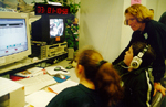
teacher Nancy Parson and Cario Middle School students review downloaded
EarthKAM images at the earth imaging team desk. The project challenges
students to become part of a real time NASA Space Shuttle mission at MUSC.
For mission information <http://www.musc.edu/cando/smoc>.
Science
teacher Nancy Parson and Cario Middle School students review downloaded
EarthKAM images at the earth imaging team desk. The project challenges
students to become part of a real time NASA Space Shuttle mission at MUSC.
For mission information <http://www.musc.edu/cando/smoc>.
More than 150 Lowcountry students from Charleston and Berkeley counties are contributing science to NASAs EarthKAM program aboard STS-99s Endeavour mission. The program is designed to let students photograph the Earth using a camera aboard the Space Shuttle.
EarthKAM uses a special digital camera that is bracket-mounted to the orbiters aft flight deck. It is controlled by student-selected sites on Earth. The project is being conducted in conjunction with Endeavours high-tech Shuttle Radar Topography Mission, a project that will provide scientists with the most precise topographic maps of the Earth.
MUSC gets tremendous benefits from being a co-sponsor in this project, said Tom OBrien, program engineering chief and instrument supervisor, Department of Pathology and Laboratory Medicine. Our participation is an investment in education, our children and the future.
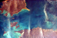 EarthKAM
image of AmhemnLand, Northern Territory in Australia.
EarthKAM
image of AmhemnLand, Northern Territory in Australia.
As Endeavour orbited just 147 miles above the Earth, students at the Student Mission Control (SMOC) room were busy scurrying around tables and workstations as they selected their daily list of targets. Students used mission maps, charts, atlas books and interactive web pages to confirm images.
The mission has done very well, said Carol Tempel, Ed.D., science coordinator for Charleston County School District and co-project director. Weve received many great images as the students learned and worked in a real time control room. As students select a geographic target, they confirm its location on the Shuttles orbital flight path map and submit its coordinates (longitude and latitude) to the mission targeting specialist team. The target is forwarded to the environmental specialist who checks the weather for the targeted location. Upon approval, the target is sent to the flight director of operations who verifies the coordinates, reassesses the weather and routes the information to the mission operations director. It is finally submitted to the EarthKAM Operations center at the University of California at San Diego. If the image is approved, the target is uplinked to the Shuttle via satellite. The image is downloaded via the Internet and is made available to participating schools to study.
Similar SMOC teams around the country have also submitted student-selected targets. The teams are connected to EarthKAM operations center through computers connected to the Internet.
OBrien and principal investigator Jim Nicholson have collaborated with volunteer MUSC staffers in the Audio/Visual Department, Center for Computing and Information Technology (CCIT), Physical Plant, Department of Pathology and Laboratory Medicine and the Department of Public Safety to provide surplus-destined computers, monitors, Internet hook-ups, communications equipment and manpower to create EarthKAMs SMOC room located at MUSCs video studio.
I like it. I want to be an astronaut and this experience gives me an idea of what really goes on during a mission, said Luis Pelaez, SMOC mission operations director and eighth grader at Drayton Hall Middle School.
Charlestons successful image list includes: Saskatchewan, Canada; AmhemLand, Northern Territory of Australia, and Charlotte, N.C. Students are able to apply valuable learning skills using Earth science, geography, space science, and English through the EarthKAM project.
Ive learned a lot about geography and how to find different places around the world, said Jessica Olsen, long-term planning team member and eighth grader at Drayton Hall. I didnt think Id have so much fun.